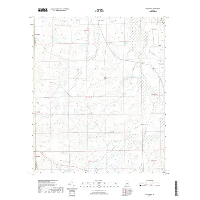
2018 Map of Fitzpatrick
USGS Topo · Published 2018About this map
Fitzpatrick and Mitchell serve as the primary focal points of this Bullock County landscape, where the agricultural traditions of the Alabama Black Belt remain visible in the land use patterns. The terrain is defined by a dense network of small water bodies and creeks, including Panther Cr, Line Cr, and Pinhook Cr, which drain into several named reservoirs such as Lake Forrer Number One and McGhee Lake Number Two. This 2018 survey reveals a rural infrastructure of county roads and logging tracks, such as High Logging Rd, that weave through the forested wetlands. For genealogists, the map identifies significant local landmarks like Mount Zion Cem and Fitzpatrick Cem, providing precise locations for these historical sites within the larger grid of the Public Land Survey System.
Find a feature on this map
40 named features on this map. Tap any name to fly to it.
Don’t see what you’re looking for? This feature index may not catch every label — zoom into the map to look around manually.
Map Details
Editions of this 2018 Fitzpatrick Map
This is the sole edition of this map. No revisions or reprints were ever made.
Other maps of this area

1953 · Montgomery
USGS Topo · 1:250,000

1955 · Phenix City
USGS Topo · 1:250,000

1956 · Montgomery
USGS Topo · 1:250,000

1957 · Phenix City
USGS Topo · 1:250,000

1957 · Montgomery
USGS Topo · 1:250,000

1958 · Phenix City
USGS Topo · 1:250,000

1958 · Mount Meigs
USGS Topo · 1:62,500
1971 · China Grove
USGS Topo · 1:24,000

1971 · Hardaway
USGS Topo · 1:24,000

1971 · Thompson
USGS Topo · 1:24,000