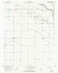
1956 Map of Five Points
USGS Topo · Published 1990About this map
Five Points emerges as a vital agricultural crossroads in this mid-1950s survey of the San Joaquin Valley. The landscape is defined by an intensive network of irrigation and industrial farming infrastructure, including the Crescent Ditch, Laguna Ditch, and Cerini Avenue Canal. The presence of several Labor Camps and a Cotton Gin near the town center highlights the era's reliance on large-scale seasonal labor and cotton production. This industrial character is further evidenced by clusters of Oil Tanks and Grain Tanks scattered across the grid. Cultural markers of the period include a Drive-in Theater and a Radio Tower on the western edge of town. Large family-named holdings like the Noble Ranch and Aladdin Ranch occupy substantial tracts between the natural courses of Elkhorn Slough and Fresno Slough, while the Wheatville (Site) serves as a reminder of earlier frontier settlements in Fresno County.
Find a feature on this map
43 named features on this map. Tap any name to fly to it.
Don’t see what you’re looking for? This feature index may not catch every label — zoom into the map to look around manually.
Map Details
Editions of this 1956 Five Points Map
3 editions found
Other maps of this area

1912 · Coalinga
USGS Topo · 1:125,000

1925 · Helm
USGS Topo · 1:31,680

1925 · San Joaquin
USGS Topo · 1:31,680

1925 · Raisin
USGS Topo · 1:31,680

1926 · Lethent
USGS Topo · 1:31,680

1927 · Burrel
USGS Topo · 1:31,680

1928 · Delta Farms No 3
USGS Topo · 1:31,680

1931 · Wheatville
USGS Topo · 1:31,680

1931 · Towne Oil Station
USGS Topo · 1:31,680

1932 · Delta Farms
USGS Topo · 1:31,680