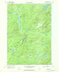
1969 Map of Five Ponds
USGS Topo · Published 1972About this map
Adirondack State Park dominates this landscape, showing the dense network of water bodies and primitive landmarks within the State Forest Preserve during the late 1960s. The northern reaches are defined by the winding Oswegatchie River, punctuated by Griffin Rapids and High Rock. The geography is remarkably fluid, centering on the Big Five Ponds and Little Five Ponds, which are surrounded by smaller basins like Big Shallow and the Washbowl. This survey predates significant modern development, preserving the wilderness character of the St Lawrence and Herkimer county line. Notable for local history and recreation, the map details established backcountry points such as Janacks Landing on Dead Creek Flow and the open terrain of The Plains near Boiling Spring. It provides a clear record of the area's natural drainage, including Sliding Falls and the isolated Muir Pond.
Find a feature on this map
48 named features on this map. Tap any name to fly to it.
Don’t see what you’re looking for? This feature index may not catch every label — zoom into the map to look around manually.
Map Details
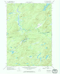
Editions of this 1969 Five Ponds Map
2 editions found
Other maps of this area

1903 · Big Moose
USGS Topo · 1:62,500

1912 · Number Four
USGS Topo · 1:62,500

1915 · Number Four
USGS Topo · 1:62,500

1916 · Oswegatchie
USGS Topo · 1:62,500

1918 · Oswegatchie
USGS Topo · 1:62,500

1919 · Cranberry Lake
USGS Topo · 1:62,500

1921 · Cranberry Lake
USGS Topo · 1:62,500

1931 · Cranberry Lake
USGS Topo · 1:62,500

1948 · Ogdensburg
USGS Topo · 1:250,000

1950 · Utica
USGS Topo · 1:250,000