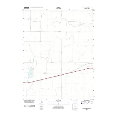
2010 Map of Flagler Reservoir
USGS Topo · Published 2010About this map
The South Fork Republican River winds through this Kit Carson County landscape, anchored by the water management infrastructure of the Flagler Dam and the accompanying Flagler Reservoir. This high plains region is defined by a rigorous grid of section roads including County Road AA and County RD 14, reflecting the agricultural organization of eastern Colorado. A notable point of transit is Kipling Crossing, located where the river intersects the local road network. The drainage pattern is further detailed by several seasonal waterways such as Duck Creek, Sand Creek, and Buffalo Creek, which reveal the natural topography beneath the rectilinear human development. The map also shows the path of Interstate 70 and the adjacent Frontage RD, illustrating the vital modern transportation corridor that parallels the older river routes.
Find a feature on this map
21 named features on this map. Tap any name to fly to it.
Don’t see what you’re looking for? This feature index may not catch every label — zoom into the map to look around manually.
Map Details
Editions of this 2010 Flagler Reservoir Map
This is the sole edition of this map. No revisions or reprints were ever made.
Other maps of this area

1954 · Limon
USGS Topo · 1:250,000

1957 · Limon
USGS Topo · 1:250,000

1958 · Limon
USGS Topo · 1:250,000

1979 · Seibert NE
USGS Topo · 1:24,000

1979 · Hugo 4 NE
USGS Topo · 1:24,000

1979 · Flagler
USGS Topo · 1:24,000
1979 · Flagler NE
USGS Topo · 1:24,000

1979 · Stratton 3 NE
USGS Topo · 1:24,000
1979 · Seibert NW
USGS Topo · 1:24,000
1979 · South of Flagler Reservoir
USGS Topo · 1:24,000