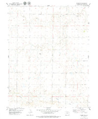
1979 Map of Seibert NW
USGS Topo · Published 1979About this map
Hell Creek and Buffalo Creek define the drainage patterns of this high plains landscape in Kit Carson County, as documented in this 1970s survey. The terrain is largely characterized by wide, open drainage basins and subtle topographic variations, typical of the region's agricultural and ranching heritage. A small cluster of activity is noted at Boren, while a standalone Storage Bin serves as a lone industrial landmark in the eastern sections of the quadrangle. This map provides a clear view of the rural infrastructure of the era, including the fine red dashed lines that indicate property boundaries and fence lines. The presence of several Well sites across the township lines of Range 50 West and Range 49 West suggests the critical importance of water management in this semi-arid portion of eastern Colorado.
Find a feature on this map
8 named features on this map. Tap any name to fly to it.
Don’t see what you’re looking for? This feature index may not catch every label — zoom into the map to look around manually.
Map Details
Editions of this 1979 Seibert NW Map
This is the sole edition of this map. No revisions or reprints were ever made.
Other maps of this area

1954 · Limon
USGS Topo · 1:250,000

1957 · Limon
USGS Topo · 1:250,000

1958 · Limon
USGS Topo · 1:250,000

1977 · Cope SE
USGS Topo · 1:24,000

1977 · Anton SE
USGS Topo · 1:24,000

1977 · Cope SW
USGS Topo · 1:24,000

1979 · Seibert NE
USGS Topo · 1:24,000

1979 · Flagler
USGS Topo · 1:24,000
1979 · Flagler NE
USGS Topo · 1:24,000
1980 · Flagler Reservoir
USGS Topo · 1:24,000