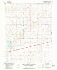
1980 Map of Flagler Reservoir
USGS Topo · Published 1980About this map
Flagler Reservoir and its adjacent State Recreation Area define the western reaches of this High Plains landscape in Kit Carson County. The terrain is characterized by the meandering South Fork Republican River and its numerous tributaries, including Duck Creek, Buffalo Creek, and Sand Creek, which carve gentle drainage patterns across the prairie. The transportation backbone of the region is clearly established by the Chicago Rock Island and Pacific railroad line, which runs parallel to the primary roadway across the central portion of the sheet. At the intersection of rail and river, the map identifies Kipling Crossing, a specific point of local transit history. Small-scale industrial activity is represented by a Gravel Pit near the riverbanks, illustrating the localized resource extraction common to this part of eastern Colorado during the late twentieth century.
Find a feature on this map
14 named features on this map. Tap any name to fly to it.
Don’t see what you’re looking for? This feature index may not catch every label — zoom into the map to look around manually.
Map Details
Editions of this 1980 Flagler Reservoir Map
This is the sole edition of this map. No revisions or reprints were ever made.
Other maps of this area

1954 · Limon
USGS Topo · 1:250,000

1957 · Limon
USGS Topo · 1:250,000

1958 · Limon
USGS Topo · 1:250,000

1979 · Seibert NE
USGS Topo · 1:24,000

1979 · Hugo 4 NE
USGS Topo · 1:24,000

1979 · Flagler
USGS Topo · 1:24,000
1979 · Flagler NE
USGS Topo · 1:24,000

1979 · Stratton 3 NE
USGS Topo · 1:24,000
1979 · Seibert NW
USGS Topo · 1:24,000
1979 · South of Flagler Reservoir
USGS Topo · 1:24,000