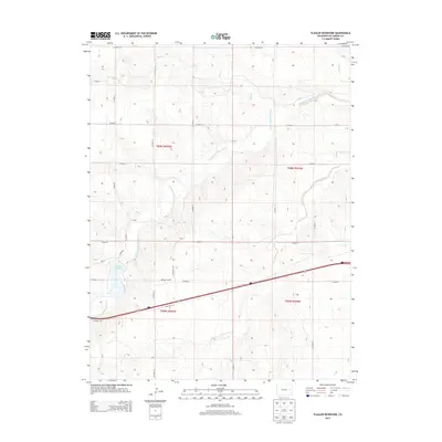
2013 Map of Flagler Reservoir
USGS Topo · Published 2013About this map
Flagler Reservoir and the winding course of the South Fork Republican River define this high plains landscape in Kit Carson County. The terrain is characterized by a high density of intermittent drainage systems, including Duck Cr, Buffalo Cr, and Sand Creek, which carve through the sectionalized prairie. A primary transportation corridor bisects the southern half of the map, where the Frontage Rd runs parallel to the interstate. Evidence of local movement across the river is found at Kipling Crossing, a specific point of interest for those studying historical transit routes or land use in this part of eastern Colorado. The map reflects a classic western township and range survey system, with a network of numbered county roads like CO Road 10 and CO Road 12 forming a rigid grid over the natural topography.
Find a feature on this map
27 named features on this map. Tap any name to fly to it.
Don’t see what you’re looking for? This feature index may not catch every label — zoom into the map to look around manually.
Map Details
Editions of this 2013 Flagler Reservoir Map
This is the sole edition of this map. No revisions or reprints were ever made.
Other maps of this area

1954 · Limon
USGS Topo · 1:250,000

1957 · Limon
USGS Topo · 1:250,000

1958 · Limon
USGS Topo · 1:250,000

1979 · Seibert NE
USGS Topo · 1:24,000

1979 · Hugo 4 NE
USGS Topo · 1:24,000

1979 · Flagler
USGS Topo · 1:24,000
1979 · Flagler NE
USGS Topo · 1:24,000

1979 · Stratton 3 NE
USGS Topo · 1:24,000
1979 · Seibert NW
USGS Topo · 1:24,000
1979 · South of Flagler Reservoir
USGS Topo · 1:24,000