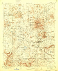
1912 Map of Flagstaff
USGS Topo · Published 1929About this map
Lowell Observatory sits prominently on the hills overlooking Flagstaff, marking the city's early status as a center for scientific inquiry during the first decade of the twentieth century. The surrounding landscape is a network of pioneer homesteads and ranches, such as Gleason's Ranch and Beasley's Ranch, scattered through the Tusayan National Forest and Coconino National Forest. The Atchison Topeka and Santa Fe railroad serves as the primary artery for the region, connecting smaller depots like Bellemont and Maine to the wider world.
Find a feature on this map
120 named features on this map. Tap any name to fly to it.
Don’t see what you’re looking for? This feature index may not catch every label — zoom into the map to look around manually.
Map Details
Editions of this 1912 Flagstaff Map
5 editions found

Other maps of this area

1886 · San Francisco Mtns
USGS Topo · 1:250,000

1886 · Chino
USGS Topo · 1:250,000

1887 · Verde
USGS Topo · 1:250,000

1887 · Prescott
USGS Topo · 1:250,000

1891 · San Francisco Mtns
USGS Topo · 1:250,000

1891 · Chino
USGS Topo · 1:250,000

1892 · Verde
USGS Topo · 1:250,000

1892 · Prescott
USGS Topo · 1:250,000

1894 · San Francisco Mtns
USGS Topo · 1:250,000

1899 · San Francisco Mtns
USGS Topo · 1:250,000