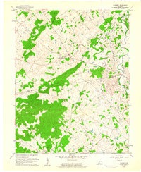
1960 Map of Flaherty
USGS Topo · Published 1961About this map
Flaherty serves as the central settlement of this 1960 landscape, where the Flaherty Sch and St Martins Ch anchor the community near the junction of several rural routes. The terrain is characterized by the prominent Sand Ridge, which bisects the area and creates a natural divide between the northern and southern drainage basins. To the northeast, the Fort Knox Military Reservation boundary encroaches on the winding path of Otter Creek, a significant water body joined by Brushy Fork.
Find a feature on this map
28 named features on this map. Tap any name to fly to it.
Don’t see what you’re looking for? This feature index may not catch every label — zoom into the map to look around manually.
Map Details
Editions of this 1960 Flaherty Map
3 editions found
Other maps of this area

1932 · Big Clifty
USGS Topo · 1:62,500

1935 · Elizabethtown
USGS Topo · 1:48,000

1936 · Vine Grove
USGS Topo · 1:62,500

1938 · Elizabethtown
USGS Topo · 1:62,500

1941 · Ekron
USGS Topo · 1:62,500

1943 · Vine Grove
USGS Topo · 1:62,500

1946 · Rock Haven
USGS Topo · 1:24,000

1946 · Fort Knox
USGS Topo · 1:24,000

1946 · Vine Grove
USGS Topo · 1:24,000

1946 · Vine Grove
USGS Topo · 1:62,500