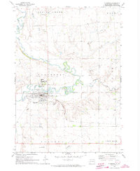
1972 Map of Flandreau
USGS Topo · Published 1973About this map
The Big Sioux River snakes through the heart of this Moody County landscape, its meanders defining the agricultural and institutional character of the early 1970s. The city of Flandreau serves as the focal point, where the Chicago Milwaukee St Paul and Pacific railroad tracks bisect the town south of the river. A significant area is dedicated to the Flandreau Indian Sch, reflecting the community's long-standing educational history.
Find a feature on this map
23 named features on this map. Tap any name to fly to it.
Don’t see what you’re looking for? This feature index may not catch every label — zoom into the map to look around manually.
Map Details
Editions of this 1972 Flandreau Map
This is the sole edition of this map. No revisions or reprints were ever made.
Other maps of this area

1953 · Watertown
USGS Topo · 1:250,000

1955 · Sioux Falls
USGS Topo · 1:250,000

1958 · Sioux Falls
USGS Topo · 1:250,000

1958 · Watertown
USGS Topo · 1:250,000

1963 · Trent
USGS Topo · 1:24,000

1964 · Flandreau SW
USGS Topo · 1:24,000

1964 · Flandreau NW
USGS Topo · 1:24,000

1967 · Elkton SW
USGS Topo · 1:24,000

1967 · Jasper NW
USGS Topo · 1:24,000

1967 · Elkton
USGS Topo · 1:24,000