
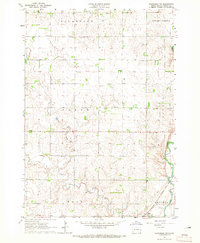
1964 Map of Flandreau SW
USGS Topo · Published 1965About this map
Egan serves as a small-town hub in this rural landscape, situated just west of the Big Sioux River and the Chicago Milwaukee St Paul and Pacific railroad. The 1960s terrain is characterized by a high concentration of rural schoolhouses and small community anchors, suggesting a well-settled agricultural district even as larger farming trends began to consolidate schools. Notable local landmarks include the Tidd Sch, Smyth Sch, and Bell Sch, alongside the Chamberlin Sch. These schools, paired with sites like the Clare Ch and Clare Cem, provide precise geographic markers for family researchers tracking the mid-century social fabric of Moody County. Waterways like Spring Creek and Squaw Creek drain into the river valley, which also supported local industry at the Gravel Pit near the southern edge of the survey.
Find a feature on this map
19 named features on this map. Tap any name to fly to it.
Don’t see what you’re looking for? This feature index may not catch every label — zoom into the map to look around manually.
Map Details
Editions of this 1964 Flandreau SW Map
2 editions found
Other maps of this area

1953 · Watertown
USGS Topo · 1:250,000

1955 · Sioux Falls
USGS Topo · 1:250,000

1958 · Sioux Falls
USGS Topo · 1:250,000

1958 · Watertown
USGS Topo · 1:250,000

1963 · Trent
USGS Topo · 1:24,000

1963 · Colman
USGS Topo · 1:24,000

1964 · Medary
USGS Topo · 1:24,000

1964 · Rutland SE
USGS Topo · 1:24,000

1964 · Flandreau NW
USGS Topo · 1:24,000

1972 · Flandreau NE
USGS Topo · 1:24,000