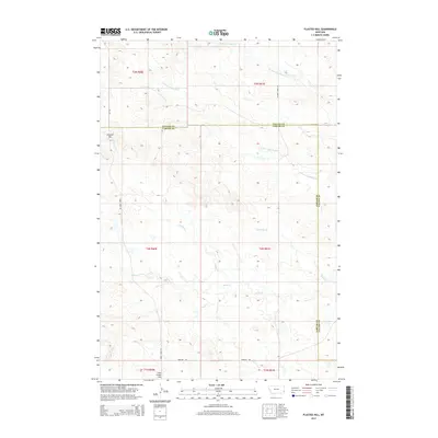
2014 Map of Flasted Hill
USGS Topo · Published 2014About this map
Flasted Hill and Coal Creek Hill dominate this southeastern Montana landscape, providing a clear view of the high ground between the drainage basins of the Little Missouri and Powder Rivers. This section of the Great Plains is defined by a dendritic network of intermittent watercourses, most notably N Fork Coal Bank Cr and Horse Cr, which have carved out the undulating terrain. The boundary between Fallon and Carter Counties bisects the quadrangle, reflecting the sparse ranching and agricultural patterns of the early twenty-first century. A few primitive roads, such as Webster Rd and Chimney Creek Rd, provide the only access through these expansive sections of rangeland, tracing the natural contours of the hills and creek beds.
Find a feature on this map
19 named features on this map. Tap any name to fly to it.
Don’t see what you’re looking for? This feature index may not catch every label — zoom into the map to look around manually.
Map Details
Editions of this 2014 Flasted Hill Map
This is the sole edition of this map. No revisions or reprints were ever made.
Other maps of this area

1953 · Miles City
USGS Topo · 1:250,000

1954 · Ekalaka
USGS Topo · 1:250,000

1956 · Ekalaka
USGS Topo · 1:250,000

1957 · Miles City
USGS Topo · 1:250,000

1958 · Miles City
USGS Topo · 1:250,000

1958 · Ekalaka
USGS Topo · 1:250,000

1965 · Ekalaka
USGS Topo · 1:250,000

1980 · Dutchmans Hill
USGS Topo · 1:24,000
1980 · Lampkin Gulch
USGS Topo · 1:24,000
1980 · Humbolt Hills
USGS Topo · 1:24,000