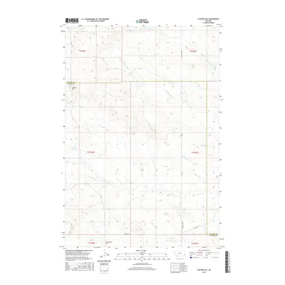
2017 Map of Flasted Hill
USGS Topo · Published 2017About this map
Flasted Hill and Coal Creek Hill dominate the skyline of this section of the Montana rangeland, where the border of Fallon and Carter counties meets. This landscape is defined by its drainage systems, with the S Fork Coal Bank Cr and N Fork Coal Bank Cr carving through the northern sections while Horse Cr and Squabble Cr meander through the southern reaches. The sparse road network, featuring Webster Rd and Chimney Creek Rd, reflects a classic Western ranching geography where vast acreage is accessed by primary county routes. The survey captures the intricate network of coulees and ridges including the eponymous Flasted Cr, offering a detailed look at the local topography before the modern digital era's significant shifts in land use.
Find a feature on this map
17 named features on this map. Tap any name to fly to it.
Don’t see what you’re looking for? This feature index may not catch every label — zoom into the map to look around manually.
Map Details
Editions of this 2017 Flasted Hill Map
This is the sole edition of this map. No revisions or reprints were ever made.
Other maps of this area

1953 · Miles City
USGS Topo · 1:250,000

1954 · Ekalaka
USGS Topo · 1:250,000

1956 · Ekalaka
USGS Topo · 1:250,000

1957 · Miles City
USGS Topo · 1:250,000

1958 · Miles City
USGS Topo · 1:250,000

1958 · Ekalaka
USGS Topo · 1:250,000

1965 · Ekalaka
USGS Topo · 1:250,000

1980 · Dutchmans Hill
USGS Topo · 1:24,000
1980 · Lampkin Gulch
USGS Topo · 1:24,000
1980 · Humbolt Hills
USGS Topo · 1:24,000