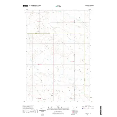
2020 Map of Flasted Hill
USGS Topo · Published 2020About this map
Flasted Hill rises as a central topographic landmark in this section of the northern Great Plains, where the boundary between Fallon County and Carter County dictates the local land management. The drainage patterns here are complex, defined by the headwaters of several intermittent streams including N Fork Coal Bank Cr and S Fork Coal Bank Cr in the north, and the meandering Horse Cr and Squabble Cr to the south. This area is characterized by wide-open ranching land and a sparse road network, primarily consisting of 101 Rd, Chimney Creek Rd, and Webster Rd. In the southern reaches, Coal Creek Hill provides an additional high point overlooking the valley of Flasted Cr, illustrating the rugged, dissected character of the Montana coulees.
Find a feature on this map
18 named features on this map. Tap any name to fly to it.
Don’t see what you’re looking for? This feature index may not catch every label — zoom into the map to look around manually.
Map Details
Editions of this 2020 Flasted Hill Map
This is the sole edition of this map. No revisions or reprints were ever made.
Other maps of this area

1953 · Miles City
USGS Topo · 1:250,000

1954 · Ekalaka
USGS Topo · 1:250,000

1956 · Ekalaka
USGS Topo · 1:250,000

1957 · Miles City
USGS Topo · 1:250,000

1958 · Miles City
USGS Topo · 1:250,000

1958 · Ekalaka
USGS Topo · 1:250,000

1965 · Ekalaka
USGS Topo · 1:250,000

1980 · Dutchmans Hill
USGS Topo · 1:24,000
1980 · Lampkin Gulch
USGS Topo · 1:24,000
1980 · Humbolt Hills
USGS Topo · 1:24,000