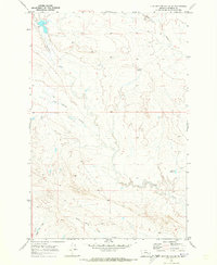
1969 Map of Flat Bottom Coulee SE
USGS Topo · Published 1973About this map
The high plains of Rosebud County are defined by an intricate network of drainage channels and vital water sources in this 1969 field-checked record. The map reveals the critical importance of water management in this arid ranching landscape, highlighted by the Absolen Reservoir in the east and the Lane Well (Flowing) near the center. Topographical detail focuses on the erosive patterns of the Flat Bottom Coulee and Stellar Creek, which carve through the landscape alongside Rattlesnake Creek. To the south, the headwaters of the North Prong Hay Creek and Ash Creek illustrate the watershed's complexity. These features provide essential context for understanding the historic land use and livestock operations of the region during the mid-20th century.
Find a feature on this map
8 named features on this map. Tap any name to fly to it.
Don’t see what you’re looking for? This feature index may not catch every label — zoom into the map to look around manually.
Map Details
Editions of this 1969 Flat Bottom Coulee SE Map
This is the sole edition of this map. No revisions or reprints were ever made.
Other maps of this area

1954 · Forsyth
USGS Topo · 1:250,000

1957 · Forsyth
USGS Topo · 1:250,000

1958 · Forsyth
USGS Topo · 1:250,000

1968 · Donleys Reservoir
USGS Topo · 1:24,000

1968 · Finch NE
USGS Topo · 1:24,000

1968 · Black Coulee
USGS Topo · 1:24,000

1969 · Rudie Coulee
USGS Topo · 1:24,000

1969 · Flat Bottom Coulee SW
USGS Topo · 1:24,000

1969 · Flat Bottom Coulee NE
USGS Topo · 1:24,000
1969 · Rough Creek SW
USGS Topo · 1:24,000