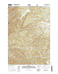
2017 Map of Flat Mountain
USGS Topo · Published 2017About this map
Siuslaw National Forest covers much of the northwestern terrain in this Benton County landscape, where the ridges of Franklin Ridge and Decker Ridge rise above a dense network of mountain drainages. The area is defined by its dramatic elevation changes, peaking at Flat Mountain and Buck Peak, with the deep incision of Hells Canyon to the east. Settled activity is concentrated along the lower creek valleys and peripheral roads, notably near the northern and eastern borders. Genealogists may find interest in the Emerick Cem located near Airport Rd and the Powell Cem situated along the slopes above Powell Cr. The map details a complex web of forest and access roads, such as Wells Creek Rd and Decker RD, which follow the contours of the land established by Greasy Cr, Spencer Cr, and Mercer Cr.
Find a feature on this map
61 named features on this map. Tap any name to fly to it.
Don’t see what you’re looking for? This feature index may not catch every label — zoom into the map to look around manually.
Map Details
Editions of this 2017 Flat Mountain Map
This is the sole edition of this map. No revisions or reprints were ever made.
Other maps of this area

1911 · Monroe
USGS Topo · 1:31,680

1911 · Inavale
USGS Topo · 1:31,680

1913 · Philomath
USGS Topo · 1:31,680

1921 · Corvallis
USGS Topo · 1:62,500

1922 · Monroe
USGS Topo · 1:62,500

1939 · Marys Peak
USGS Topo · 1:62,500

1939 · Monroe
USGS Topo · 1:62,500

1942 · Marys Peak
USGS Topo · 1:62,500

1942 · Alsea
USGS Topo · 1:62,500

1942 · Monroe
USGS Topo · 1:62,500