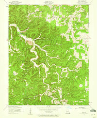
1954 Map of Flat
USGS Topo · Published 1959About this map
Mark Twain National Forest dominates the Ozark landscape on this 1950s survey of Missouri's Phelps County. The terrain is defined by the winding course of Spring Creek, which is fed by numerous cold-water sources including Relfe Spring and Cave Spring. This era shows a distributed rural community structure where small schools and churches served families living deep within the hollows. Academic and spiritual life was localized at sites such as West Point School, Smith Church, and Rambo Church. The map captures the intricate network of drainage and ridges, with names like Democrat Hollow and Chambers Hollow reflecting local history and family homesteads. The small settlement of Flat stands as a primary point of reference in a region where the geography of the creek valleys determined the placement of roads and homesteads before significant modern development altered these rural corridors.
Find a feature on this map
32 named features on this map. Tap any name to fly to it.
Don’t see what you’re looking for? This feature index may not catch every label — zoom into the map to look around manually.
Map Details
Editions of this 1954 Flat Map
2 editions found
Other maps of this area

1912 · Rolla
USGS Topo · 1:62,500

1936 · Waynesville
USGS Topo · 1:48,000

1937 · Edgar Springs
USGS Topo · 1:48,000

1941 · Big Piney
USGS Topo · 1:62,500

1942 · Waynesville
USGS Topo · 1:62,500

1943 · Big Piney
USGS Topo · 1:62,500

1944 · Waynesville
USGS Topo · 1:62,500

1945 · Edgar Springs
USGS Topo · 1:62,500

1949 · Rolla
USGS Topo · 1:250,000
1950 · Kaintuck Hollow
USGS Topo · 1:24,000