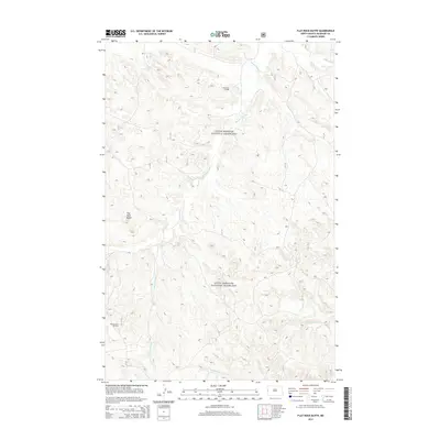
2014 Map of Flat Rock Butte
USGS Topo · Published 2014About this map
Little Missouri National Grassland encompasses this high plains landscape in McKenzie County, defined by a complex drainage network and modern energy extraction. The terrain is marked by distinctive elevations like Flat Rock Butte, while the water system is dominated by the winding paths of Bennie Peer Cr and Poker Jim Cr. This 2014 survey documents the industrial footprint of the region, specifically the Poker Jim Oilfield in the north and the Bicentennial Oil Field to the southwest. The map details a dense grid of local access roads, including 814 and 815, which serve the various oil pads and grazing lands. Along the southern border, the headwaters of N Fork Prairie Dog Cr and Cinnamon Cr cut through the grassland, illustrating the persistent erosion patterns of the western North Dakota badlands.
Find a feature on this map
29 named features on this map. Tap any name to fly to it.
Don’t see what you’re looking for? This feature index may not catch every label — zoom into the map to look around manually.
Map Details
Editions of this 2014 Flat Rock Butte Map
This is the sole edition of this map. No revisions or reprints were ever made.
Other maps of this area

1953 · Watford City
USGS Topo · 1:250,000

1957 · Watford City
USGS Topo · 1:250,000

1967 · Watford City
USGS Topo · 1:250,000

1970 · Eagle Draw
USGS Topo · 1:24,000
1972 · Phillip Spring
USGS Topo · 1:24,000

1972 · Sheep Creek
USGS Topo · 1:24,000
1972 · Burning Mine Butte
USGS Topo · 1:24,000

1974 · Trotters SE
USGS Topo · 1:24,000

1974 · Trotters
USGS Topo · 1:24,000
1974 · Squaw Gap
USGS Topo · 1:24,000