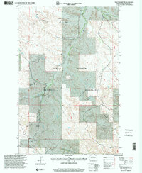
1997 Map of Flat Rock Butte
USGS Topo · Published 2001About this map
Little Missouri National Grassland dominates this corner of McKenzie County, where the high plains break into a network of drainages and working lands. The landscape is a mix of conservation and resource extraction, defined by the Poker Jim Oil Field in the north and the Bicentennial Oil Field further south. Isolated homesteads such as Rivet Ranch and the Rindahl Ranch anchor the rural survey, while the namesake Flat Rock Butte serves as a prominent natural landmark rising above the 4WD trails and section lines.
Find a feature on this map
19 named features on this map. Tap any name to fly to it.
Don’t see what you’re looking for? This feature index may not catch every label — zoom into the map to look around manually.
Map Details
Editions of this 1997 Flat Rock Butte Map
This is the sole edition of this map. No revisions or reprints were ever made.
Other maps of this area

1953 · Watford City
USGS Topo · 1:250,000

1957 · Watford City
USGS Topo · 1:250,000

1967 · Watford City
USGS Topo · 1:250,000

1970 · Eagle Draw
USGS Topo · 1:24,000
1972 · Phillip Spring
USGS Topo · 1:24,000

1972 · Sheep Creek
USGS Topo · 1:24,000
1972 · Burning Mine Butte
USGS Topo · 1:24,000

1974 · Trotters SE
USGS Topo · 1:24,000

1974 · Trotters
USGS Topo · 1:24,000
1974 · Squaw Gap
USGS Topo · 1:24,000