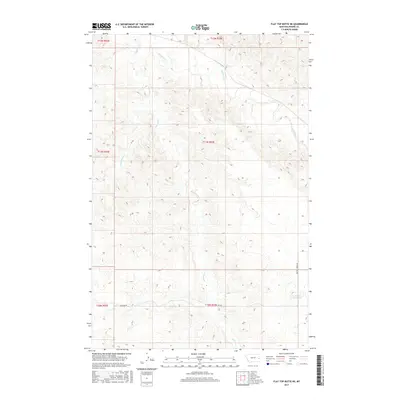
2017 Map of Flat Top Butte NE
USGS Topo · Published 2017About this map
O'Fallon Cr and its tributaries define the drainage patterns of this Prairie County landscape during the early 21st century. The map provides a detailed view of the sectional survey system across townships T10N through T12N, showing how early 20th-century land divisions persist in the modern era. While much of the area remains open rangeland, local infrastructure is concentrated along unpaved routes like Flat Top Rd and Whitney Creek Rd. A notable localized water feature, the Airport Reservoir, sits near the eastern boundary, illustrating how water management is critical in this semi-arid region. These small creeks, including Whitney Cr and Fox Cr, carve subtle topographical variations into the high plains, guiding the placement of the few access roads that crisscross the territory.
Find a feature on this map
12 named features on this map. Tap any name to fly to it.
Don’t see what you’re looking for? This feature index may not catch every label — zoom into the map to look around manually.
Map Details
Editions of this 2017 Flat Top Butte NE Map
This is the sole edition of this map. No revisions or reprints were ever made.
Other maps of this area

1953 · Miles City
USGS Topo · 1:250,000

1957 · Miles City
USGS Topo · 1:250,000

1958 · Miles City
USGS Topo · 1:250,000

1966 · Fallon
USGS Topo · 1:24,000

1966 · Marsh SW
USGS Topo · 1:24,000

1969 · Little Whitney Creek
USGS Topo · 1:24,000

1969 · Flat Top Butte SW
USGS Topo · 1:24,000

1969 · Flat Top Butte
USGS Topo · 1:24,000

1969 · Flat Top Butte NE
USGS Topo · 1:24,000
1972 · Fallon SW
USGS Topo · 1:24,000