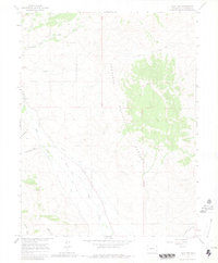
1964 Map of Flat Top
USGS Topo · Published 1981About this map
Gunnison National Forest dominates the eastern half of this landscape, rising to the prominent plateau of Flat Top. Along the western reaches, the topography is defined by the complex water management systems serving the valley, including the Teachout Ditch, May Bohm Ditch, and Lone Pine Ditch. The presence of the Old Railroad Grade near Ohio Creek speaks to the region's transport history, while the Highline Gunnison Canal at the southeastern edge marks the transition toward the settlement of Almont. The map also captures smaller details of resource use, from a solitary Mine in the northwest to the Gaging Sta along the creek, reflecting a period when mountain irrigation and legacy rail routes still dictated the local geography.
Find a feature on this map
18 named features on this map. Tap any name to fly to it.
Don’t see what you’re looking for? This feature index may not catch every label — zoom into the map to look around manually.
Map Details
Editions of this 1964 Flat Top Map
3 editions found
Other maps of this area

1888 · Crested Butte
USGS Topo · 1:62,500

1888 · Anthracite
USGS Topo · 1:62,500

1889 · Crested Butte
USGS Topo · 1:62,500

1889 · Anthracite
USGS Topo · 1:62,500

1893 · Anthracite
USGS Topo · 1:62,500

1893 · Crested Butte
USGS Topo · 1:62,500

1894 · Anthracite
USGS Topo · 1:62,500

1954 · Mc Intosh Mountain
USGS Topo · 1:24,000

1954 · Gunnison
USGS Topo · 1:24,000

1956 · Montrose
USGS Topo · 1:250,000