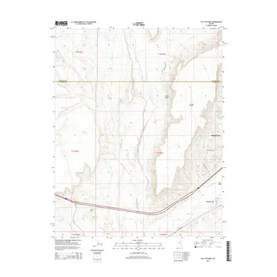
2014 Map of Flat Top Mesa
USGS Topo · Published 2014About this map
The Virgin River carves through the arid landscape of the Mojave Desert in this 2014 survey, highlighting the vital relationship between water and settlement in southern Nevada. Near the southeastern corner, the communities of Mesquite and Bunkerville occupy the fertile Virgin Valley, where the Bunkerville Ditch provides essential irrigation. The topography is dominated by the massive Flat Top Mesa, which rises sharply between Toquop Wash and the river valley. Evidence of modern infrastructure is visible through residential street names like Ben Franklin Way and Isaac Newton Dr in the developing outskirts of Mesquite. Away from the river, the terrain turns increasingly dry, marked only by the Sink Reservoir and the prominent elevation of Virgin Hill, illustrating the stark boundary between the irrigated corridor and the surrounding desert wilderness.
Find a feature on this map
21 named features on this map. Tap any name to fly to it.
Don’t see what you’re looking for? This feature index may not catch every label — zoom into the map to look around manually.
Map Details
Editions of this 2014 Flat Top Mesa Map
This is the sole edition of this map. No revisions or reprints were ever made.
Other maps of this area

1886 · Saint Thomas
USGS Topo · 1:250,000

1893 · Saint Thomas
USGS Topo · 1:250,000

1954 · Las Vegas
USGS Topo · 1:250,000

1957 · Las Vegas
USGS Topo · 1:250,000

1957 · Mesquite
USGS Topo · 1:62,500

1958 · Virgin Peak
USGS Topo · 1:62,500

1958 · Overton
USGS Topo · 1:62,500

1959 · Las Vegas
USGS Topo · 1:250,000

1962 · Las Vegas
USGS Topo · 1:250,000
1969 · Davidson Peak
USGS Topo · 1:24,000