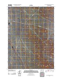
2011 Map of Flat Top Mountain SE
USGS Topo · Published 2011About this map
Old Ion Hwy and Bowden Ranch Rd intersect this high desert expanse in southeastern Malheur County, marking the primary human infrastructure in a landscape defined by drainage patterns and volcanic terrain. The eastern edge of the map is dominated by the Bowden Hills, which rise above the surrounding flats to overlook a topographic depression known as The Basin. This 2011 survey captures the area's transition between isolated ranching access routes and the open rangeland characteristic of the Oregon high desert, offering a precise view of the geographic features that have historically dictated movement and land use in this sparsely populated region.
Find a feature on this map
4 named features on this map. Tap any name to fly to it.
Don’t see what you’re looking for? This feature index may not catch every label — zoom into the map to look around manually.
Map Details
Editions of this 2011 Flat Top Mountain SE Map
This is the sole edition of this map. No revisions or reprints were ever made.
Other maps of this area

1955 · Jordan Valley
USGS Topo · 1:250,000

1957 · Jordan Valley
USGS Topo · 1:250,000

1958 · Jordan Valley
USGS Topo · 1:250,000

1979 · Bowden Ranch
USGS Topo · 1:24,000

1979 · Anderson Reservoir
USGS Topo · 1:24,000

1979 · Flat Top Mtn SE
USGS Topo · 1:24,000
1979 · The Basin
USGS Topo · 1:24,000
1980 · Flat Top Mtn
USGS Topo · 1:24,000

1980 · Rome State Airport
USGS Topo · 1:24,000
1982 · Basque
USGS Topo · 1:24,000