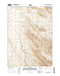
2014 Map of Flat Top Mountain SE
USGS Topo · Published 2014About this map
Black Hills and the Red Hills anchor this high desert landscape in Malheur County, where the topography transitions into a broad depression known as The Basin. The map captures a region defined more by its routes than by permanent settlements, dominated by the path of the Old Ion Hwy as it cuts across the township lines of t34s r39e and t35s r40e. Ranching heritage is evidenced by the presence of Bowden Ranch Rd and the localized designation of the Bowden Hls. A rare water feature in this arid environment, the Bowden Guzzler, reflects the essential infrastructure needed to support livestock or wildlife in this part of southeastern Oregon. The map's layout highlights the section-line geometry of the Public Land Survey System, illustrating how human boundaries were superimposed on the natural undulations of the Oregon range.
Find a feature on this map
11 named features on this map. Tap any name to fly to it.
Don’t see what you’re looking for? This feature index may not catch every label — zoom into the map to look around manually.
Map Details
Editions of this 2014 Flat Top Mountain SE Map
This is the sole edition of this map. No revisions or reprints were ever made.
Other maps of this area

1955 · Jordan Valley
USGS Topo · 1:250,000

1957 · Jordan Valley
USGS Topo · 1:250,000

1958 · Jordan Valley
USGS Topo · 1:250,000

1979 · Bowden Ranch
USGS Topo · 1:24,000

1979 · Anderson Reservoir
USGS Topo · 1:24,000

1979 · Flat Top Mtn SE
USGS Topo · 1:24,000
1979 · The Basin
USGS Topo · 1:24,000
1980 · Flat Top Mtn
USGS Topo · 1:24,000

1980 · Rome State Airport
USGS Topo · 1:24,000
1982 · Basque
USGS Topo · 1:24,000