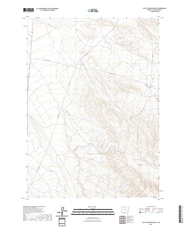
2023 Map of Flat Top Mountain SE
USGS Topo · Published 2023About this map
Old Ion Hwy and Bowden Ranch Rd intersect this corner of Malheur County, providing modern access to a landscape shaped by distinct topographic regions. The terrain is defined by the Black Hills in the north and the Red Hills to the east, transitioning into the Bowden Hills further south. Between these elevations lies the catchment area known as The Basin, illustrating the complex drainage and ridge patterns characteristic of the Oregon high desert. This 2023 survey records the modern road network and ranch access points within townships T34S and T35S, serving as a contemporary record of land use and navigation in a sparsely populated but geographically varied portion of the state.
Find a feature on this map
11 named features on this map. Tap any name to fly to it.
Don’t see what you’re looking for? This feature index may not catch every label — zoom into the map to look around manually.
Map Details
Editions of this 2023 Flat Top Mountain SE Map
This is the sole edition of this map. No revisions or reprints were ever made.
Other maps of this area

1955 · Jordan Valley
USGS Topo · 1:250,000

1957 · Jordan Valley
USGS Topo · 1:250,000

1958 · Jordan Valley
USGS Topo · 1:250,000

1979 · Bowden Ranch
USGS Topo · 1:24,000

1979 · Anderson Reservoir
USGS Topo · 1:24,000

1979 · Flat Top Mtn SE
USGS Topo · 1:24,000
1979 · The Basin
USGS Topo · 1:24,000
1980 · Flat Top Mtn
USGS Topo · 1:24,000

1980 · Rome State Airport
USGS Topo · 1:24,000
1982 · Basque
USGS Topo · 1:24,000