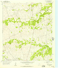
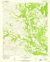
1954 Map of Flat Top Peak
USGS Topo · Published 1957About this map
Flat Top Peak and Boys Peak dominate the topography of this central Texas landscape, where the winding drainages of School Creek and Patterson Creek carve through the limestone terrain. The 1950s infrastructure is clearly defined, showing the Gulf Colorado and Santa Fe railroad cutting across the southern edge near the Lampasas Airport. A local social center, the Pecan Grove Community Clubhouse, sits along the American Legion Memorial Highway, marking a gathering point for the rural population of the era. The presence of a Caliche Pit and a Gravel Pit indicates the importance of local material extraction for road building and maintenance in this ranching country. Throughout the quadrangle, smaller watercourses like Little Lucy Creek and Lucy Creek emphasize the dendritic drainage pattern characteristic of the Lampasas County region.
Find a feature on this map
15 named features on this map. Tap any name to fly to it.
Don’t see what you’re looking for? This feature index may not catch every label — zoom into the map to look around manually.
Map Details
Editions of this 1954 Flat Top Peak Map
This is the sole edition of this map. No revisions or reprints were ever made.
Other maps of this area

1887 · Lampasas
USGS Topo · 1:125,000

1894 · Lampasas
USGS Topo · 1:125,000

1954 · Brownwood
USGS Topo · 1:250,000

1954 · Evant
USGS Topo · 1:62,500

1954 · Lampasas
USGS Topo · 1:62,500

1954 · Lampasas
USGS Topo · 1:24,000
1954 · Izoro
USGS Topo · 1:24,000
1954 · Rumley
USGS Topo · 1:24,000
1954 · Kempner
USGS Topo · 1:24,000
1954 · Adamsville
USGS Topo · 1:24,000