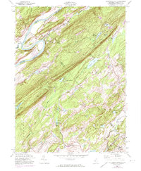
1954 Map of Flatbrookville
USGS Topo · Published 1974About this map
Kittatinny Mountain dominates the landscape in this 1954 revision, with the Appalachian Trail tracing its spine across the Pahaquarry and Hardwick border. The Delaware River makes a dramatic turn at Wallpack Bend, carving through the valley near Sambo Island. This map documents a transitional period for the Delaware Water Gap area, showing the early infrastructure of youth camps such as Camp No-Be-Bo-Sco and Camp Mohican alongside long-established rural centers.
Find a feature on this map
60 named features on this map. Tap any name to fly to it.
Don’t see what you’re looking for? This feature index may not catch every label — zoom into the map to look around manually.
Map Details
Editions of this 1954 Flatbrookville Map
4 editions found
Other maps of this area

1888 · Hackettstown
USGS Topo · 1:62,500

1891 · Wallpack
USGS Topo · 1:62,500

1891 · Delaware Water Gap
USGS Topo · 1:62,500

1893 · Delaware Water Gap
USGS Topo · 1:62,500

1893 · Wallpack
USGS Topo · 1:62,500

1894 · Hackettstown
USGS Topo · 1:62,500

1898 · Hackettstown
USGS Topo · 1:62,500

1900 · Raritan
USGS Topo · 1:125,000

1905 · Raritan
USGS Topo · 1:125,000

1905 · Hackettstown
USGS Topo · 1:62,500
Featured Places
- Blairstown, NJ
- Stillwater Township, NJ
- Fredon Township, NJ
- Hardwick Township, NJ
- Flatbrookville, Walpack Township