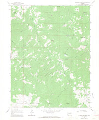
1963 Map of Flatiron Mountain
USGS Topo · Published 1967About this map
White River National Forest defines the character of this high-elevation landscape on the border of Garfield and Mesa counties. The topography is dominated by massive landforms such as Grand Mesa and Flatiron Mountain, where the terrain drops sharply into a network of drainages including West Divide Creek and Salt Creek. The area's mid-century utility is evident in the Highline Ditch and various gas wells and drill holes that punctuate the mountain ridges. Human activity is largely centered on resource management and backcountry transit, highlighted by the Cayton Guard Station and a system of jeep and pack trails. These routes connect isolated landmarks like Mosquito Lake and named peaks such as Flagpole Mountain and Baldy Mtn. The detailed contouring illustrates the complex gulch systems, including Cayton Gulch and Wade Gulch, which feed the regional watershed.
Find a feature on this map
39 named features on this map. Tap any name to fly to it.
Don’t see what you’re looking for? This feature index may not catch every label — zoom into the map to look around manually.
Map Details
Editions of this 1963 Flatiron Mountain Map
4 editions found
Other maps of this area

1957 · Leadville
USGS Topo · 1:250,000

1959 · Leadville
USGS Topo · 1:250,000

1960 · Leadville
USGS Topo · 1:250,000

1961 · Porter Mountain
USGS Topo · 1:24,000

1961 · Spruce Mountain
USGS Topo · 1:24,000

1962 · Leadville
USGS Topo · 1:250,000
1963 · Center Mountain
USGS Topo · 1:24,000
1963 · Hightower Mountain
USGS Topo · 1:24,000
1963 · Hunter Mesa
USGS Topo · 1:24,000
1963 · Gibson Gulch
USGS Topo · 1:24,000