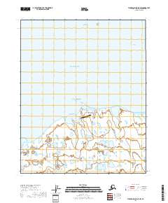
2018 Map of Flaxman Island A-5 NW
USGS Topo · Published 2018About this map
Bullen Point Air Force Station sits on the edge of the Beaufort Sea, marking a cold-war era coastal defense presence along the remote northern shoreline of Alaska. This survey reveals a landscape dominated by the intricate interplay of coastal lagoons and the transition from the mainland at Bullen Point to the offshore environment of the Stockton Islands. The waters of Mikkelsen Bay and the navigational opening at Challenge Entrance define the maritime character of the region. The map highlights the vast, pond-strewn tundra typical of the North Slope, where countless small water bodies stretch inland across the township grids of T9N and T10N.
Find a feature on this map
10 named features on this map. Tap any name to fly to it.
Don’t see what you’re looking for? This feature index may not catch every label — zoom into the map to look around manually.
Map Details
Editions of this 2018 Flaxman Island A-5 NW Map
This is the sole edition of this map. No revisions or reprints were ever made.
Other maps of this area

1951 · Beechey Point
USGS Topo · 1:250,000

1955 · Flaxman Island
USGS Topo · 1:250,000

1955 · Beechey Point
USGS Topo · 1:250,000

1955 · Beechey Point B-1
USGS Topo · 1:63,360

1955 · Flaxman Island A-5
USGS Topo · 1:63,360

1955 · Beechey Point A-1
USGS Topo · 1:63,360
1955 · Flaxman Island B-5
USGS Topo · 1:63,360

1960 · Beechey Point
USGS Topo · 1:250,000
1962 · Beechey Point A-1
USGS Topo · 1:50,000
1962 · Beechey Point B-1
USGS Topo · 1:50,000