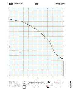
2018 Map of Flaxman Island B-5 SW
USGS Topo · Published 2018About this map
Beaufort Sea waters dominate this Arctic coastline, where the land meets the sea along the remote North Slope. This 2018 survey depicts a series of barrier islands including Pole Island, Belvedere Island, and the Stockton Islands, which provide crucial protection to the mainland shore from the northern elements. The map illustrates the Public Land Survey System grid across the transition from coastal waters into several townships, specifically t11n r20e, t11n r21e, t10n r20e, and t10n r21e. The layout of these islands reflects the dynamic nature of the Alaskan coast, serving as key navigational and topographical markers in an area otherwise defined by its maritime expanse.
Find a feature on this map
8 named features on this map. Tap any name to fly to it.
Don’t see what you’re looking for? This feature index may not catch every label — zoom into the map to look around manually.
Map Details
Editions of this 2018 Flaxman Island B-5 SW Map
This is the sole edition of this map. No revisions or reprints were ever made.
Other maps of this area

1951 · Beechey Point
USGS Topo · 1:250,000

1955 · Flaxman Island
USGS Topo · 1:250,000

1955 · Beechey Point
USGS Topo · 1:250,000

1955 · Beechey Point B-1
USGS Topo · 1:63,360

1955 · Flaxman Island A-5
USGS Topo · 1:63,360

1955 · Beechey Point A-1
USGS Topo · 1:63,360
1955 · Flaxman Island B-5
USGS Topo · 1:63,360

1960 · Beechey Point
USGS Topo · 1:250,000
1962 · Beechey Point A-1
USGS Topo · 1:50,000
1962 · Beechey Point B-1
USGS Topo · 1:50,000