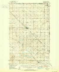
1950 Map of Flaxton
USGS Topo · Published 1950About this map
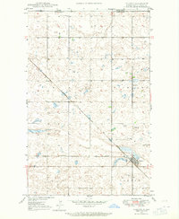
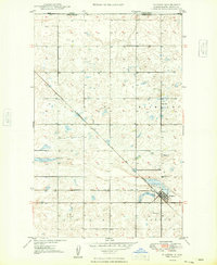
The international border between Canada and the United States defines the northern edge of this North Dakota landscape, where the settlements of Northgate and Flaxton serve as critical nodes in the agricultural and rail network of the mid-20th century. This survey, conducted as part of the Missouri River Basin development, details a region structured by township lines and the diagonal path of the Minneapolis Sault Ste Marie and St Paul railroad. The map records a dense social infrastructure for a rural area, noting numerous numbered schoolhouses and community hubs like Danish Ch, Woburn Sch, and Clayton Sch. Industrial activity is evident in the Strip Mine and Gravel Pit, while local aviation is represented by a small Landing Field. Waterways like Stony Run and Shockley Slough provide the primary drainage through the rolling prairie of Burke and Ward counties.
Find a feature on this map
32 named features on this map. Tap any name to fly to it.
Don’t see what you’re looking for? This feature index may not catch every label — zoom into the map to look around manually.
Map Details
Editions of this 1950 Flaxton Map
This is the sole edition of this map. No revisions or reprints were ever made.
Historical Maps of Bowbells Through Time
8 maps found