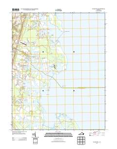
2013 Map of Fleets Bay
USGS Topo · Published 2013About this map
The town of Kilmarnock and the intricate shoreline of the Northern Neck define this coastal landscape where the Chesapeake Bay meets a network of tidal creeks and inlets. The settlement pattern reflects the area's maritime reliance, with points of interest like Kilmarnock Wharf and the Cotton Patch Bar Light marking the transition from land to water. Numerous small communities such as Ditchley, Byrdton, Ocran, and Foxwells are dispersed among the necks and points, including Bluff Point Neck and Fleets Bay Neck. The terrain is characterized by frequent coves and prongs, such as Indian Cr and Dividing Cr, which suggest a long history of water-based commerce and recreation. Regional transportation is anchored by the Jessie Dupont Memorial Hwy and local aviation facilities like Longbranch Airport and Kilmarnock/Tolbert Field Airport, illustrating the modern infrastructure supporting these traditional waterfront settlements.
Find a feature on this map
58 named features on this map. Tap any name to fly to it.
Don’t see what you’re looking for? This feature index may not catch every label — zoom into the map to look around manually.
Map Details
Editions of this 2013 Fleets Bay Map
This is the sole edition of this map. No revisions or reprints were ever made.
Other maps of this area

1916 · Kilmarnock
USGS Topo · 1:48,000

1917 · Heathsville
USGS Topo · 1:48,000

1917 · Kilmarnock
USGS Topo · 1:62,500

1917 · Ewell
USGS Topo · 1:62,500

1942 · Kilmarnock
USGS Topo · 1:62,500

1943 · Richmond
USGS Topo · 1:250,000

1944 · Reedville
USGS Topo · 1:31,680

1948 · Deltaville
USGS Topo · 1:24,000
1949 · Irvington
USGS Topo · 1:24,000
1949 · Fleets Bay
USGS Topo · 1:24,000