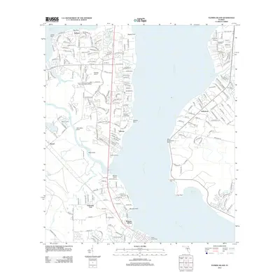
2012 Map of Fleming Island
USGS Topo · Published 2012About this map
Saint Johns River defines the geography of this corridor, where the wide river bend creates a dramatic landscape of points and coves including Popo Point and Hallowes Cove. The 2012 survey illustrates the dense residential developments of Fleming Island and Magnolia Point, showing a transition from the historic riverfront settlements like Hibernia and Switzerland to modern suburban infrastructure. Significant public works, such as the County Fleming Island Regional Wastewater Treatment Facility and the Black Creek Tower, are documented alongside recreational landmarks like the Lakes Golf Course and Amity Anchorage Marina. On the western shore of the river, Magnolia Springs and Neilhurst sit at the edge of tidal waters such as Doctors Lake and Swimming Pen Cr, highlighting the region's reliance on its complex network of waterways and bridges for navigation and leisure.
Find a feature on this map
111 named features on this map. Tap any name to fly to it.
Don’t see what you’re looking for? This feature index may not catch every label — zoom into the map to look around manually.
Map Details
Editions of this 2012 Fleming Island Map
This is the sole edition of this map. No revisions or reprints were ever made.
Other maps of this area

1917 · Orange Park
USGS Topo · 1:62,500

1918 · Middleburg
USGS Topo · 1:62,500

1918 · Orange Park
USGS Topo · 1:62,500

1941 · Middleburg
USGS Topo · 1:62,500

1942 · Ates Creek
USGS Topo · 1:62,500

1947 · Bostwick
USGS Topo · 1:50,000

1948 · Jacksonville
USGS Topo · 1:250,000

1949 · Green Cove Springs
USGS Topo · 1:24,000

1949 · Middleburg
USGS Topo · 1:24,000

1949 · Jacksonville Heights
USGS Topo · 1:24,000