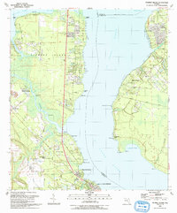
1992 Map of Fleming Island
USGS Topo · Published 1993About this map
St Johns River defines the landscape of this 1992 survey, separating the burgeoning suburban developments of Fleming Island from the historic riverfront communities of Switzerland and Fruit Cove. The map illustrates a transitional period for Clay County, where modern infrastructure like the Water Treatment Plant and new residential subdivisions coexist with older landmarks. On the western shore, the community of Hibernia and its landmark St Margaret Ch reflect the area's long-standing riverine identity, while the southern reach of the island features Magnolia Springs and the northern edge of Green Cove Springs. Across the wide water, the eastern bank is marked by Remington Park and Cunningham Creek, showing the late-century residential expansion into St. Johns County. Notable inland features include Swimming Pen Creek and the marshy corridors of Moccasin Slough, illustrating the intricate network of wetlands that shaped local navigation and settlement patterns before the extensive build-out of the late 20th century.
Find a feature on this map
55 named features on this map. Tap any name to fly to it.
Don’t see what you’re looking for? This feature index may not catch every label — zoom into the map to look around manually.
Map Details
Editions of this 1992 Fleming Island Map
This is the sole edition of this map. No revisions or reprints were ever made.
Other maps of this area

1917 · Orange Park
USGS Topo · 1:62,500

1918 · Middleburg
USGS Topo · 1:62,500

1918 · Orange Park
USGS Topo · 1:62,500

1941 · Middleburg
USGS Topo · 1:62,500

1942 · Ates Creek
USGS Topo · 1:62,500

1947 · Bostwick
USGS Topo · 1:50,000

1948 · Jacksonville
USGS Topo · 1:250,000

1949 · Green Cove Springs
USGS Topo · 1:24,000

1949 · Middleburg
USGS Topo · 1:24,000

1949 · Jacksonville Heights
USGS Topo · 1:24,000