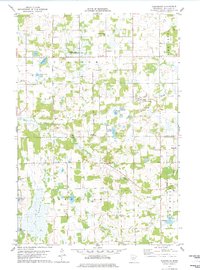
1978 Map of Flensburg
USGS Topo · Published 1978About this map
The Swan River and Pike Creek define the drainage of this central Minnesota landscape, where the settlements of Flensburg and Sobieski anchor the local community. By the late 1970s, the infrastructure of the region was a mix of active utility corridors and historical transport routes, evidenced by a Pipeline running through the center and an Old Railroad Grade tracing an east-west path across the northern reaches.
Find a feature on this map
32 named features on this map. Tap any name to fly to it.
Don’t see what you’re looking for? This feature index may not catch every label — zoom into the map to look around manually.
Map Details
Editions of this 1978 Flensburg Map
This is the sole edition of this map. No revisions or reprints were ever made.
Other maps of this area

1947 · Flensburg
USGS Topo · 1:25,000

1948 · Belle Prairie
USGS Topo · 1:62,500

1948 · Cushing
USGS Topo · 1:62,500

1948 · Little Falls
USGS Topo · 1:62,500

1950 · Swanville
USGS Topo · 1:62,500

1950 · Belle Prairie
USGS Topo · 1:62,500

1950 · Little Falls
USGS Topo · 1:62,500

1950 · Cushing
USGS Topo · 1:62,500

1951 · Flensburg
USGS Topo · 1:25,000

1953 · Brainerd
USGS Topo · 1:250,000