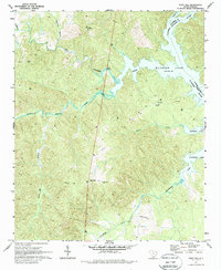
1971 Map of Flint Hill
USGS Topo · Published 1987About this map
Wateree Lake and its intricate shoreline dominate the eastern portion of this Fairfield County landscape, where the confluence of the Catawba River and Wateree River forms a critical water system. The terrain is defined by a dense network of tributaries including Wateree Creek, Little Wateree Creek, and Dutchmans Creek. Small community centers and rural hubs are scattered throughout the upland areas, anchored by local institutions such as Zion Ch and White Oak Ch.
Find a feature on this map
23 named features on this map. Tap any name to fly to it.
Don’t see what you’re looking for? This feature index may not catch every label — zoom into the map to look around manually.
Map Details
Editions of this 1971 Flint Hill Map
2 editions found
Other maps of this area

1904 · Columbia
USGS Topo · 1:125,000

1941 · Spartanburg
USGS Topo · 1:250,000

1942 · Camden
USGS Topo · 1:125,000

1953 · Spartanburg
USGS Topo · 1:250,000

1960 · Spartanburg
USGS Topo · 1:250,000

1963 · Spartanburg
USGS Topo · 1:250,000

1964 · Spartanburg
USGS Topo · 1:250,000

1968 · Lancaster SE
USGS Topo · 1:24,000
1969 · Great Falls
USGS Topo · 1:24,000
1969 · Winnsboro
USGS Topo · 1:24,000