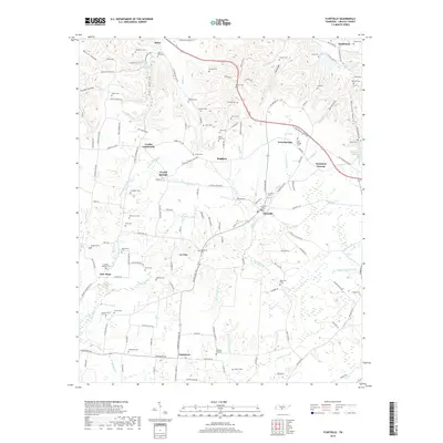
2019 Map of Flintville
USGS Topo · Published 2019About this map
Flintville and Kelso anchor this Lincoln County landscape, where the Flint River and its numerous tributaries like Big Huckleberry Cr and Merrill Br carve through the terrain. The map is particularly rich for genealogical research, documenting dozens of family-named burial grounds including Taylor-Gray Cem, McClellan Cem, and Hopkins-Eastland Cem. These sites, often situated near small crossroads like Brighton and Corder Crossroads, reflect the deep-rooted settlement patterns of the region.
Find a feature on this map
162 named features on this map. Tap any name to fly to it.
Don’t see what you’re looking for? This feature index may not catch every label — zoom into the map to look around manually.
Map Details
Editions of this 2019 Flintville Map
This is the sole edition of this map. No revisions or reprints were ever made.
Other maps of this area

1888 · Scottsboro
USGS Topo · 1:125,000

1888 · Huntsville
USGS Topo · 1:125,000

1892 · Huntsville
USGS Topo · 1:125,000

1892 · Scottsboro
USGS Topo · 1:125,000

1936 · King Cove
USGS Topo · 1:24,000

1936 · Flintville
USGS Topo · 1:24,000

1936 · Fisk
USGS Topo · 1:24,000

1936 · Lincoln
USGS Topo · 1:24,000

1936 · Huntland
USGS Topo · 1:24,000
1936 · New Market
USGS Topo · 1:24,000