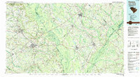
1983 Map of Florence
USGS Topo · Published 1985About this map
The Great Pee Dee River and its intricate network of tributaries dominate this 1980s landscape, illustrating the deep connection between the region's river systems and its growth. Large bottomland features like Witherspoon Island and the Pee Dee Islands are surrounded by an extensive network of swamps, including Bear Swamp and Gapway Swamp. This water-rich geography is juxtaposed with the industrial reach of the Seaboard Coast Line railroad, which links established hubs like Florence, Darlington, and Marion.
Find a feature on this map
119 named features on this map. Tap any name to fly to it.
Don’t see what you’re looking for? This feature index may not catch every label — zoom into the map to look around manually.
Map Details
Editions of this 1983 Florence Map
This is the sole edition of this map. No revisions or reprints were ever made.
Other maps of this area

1920 · Mayesville
USGS Topo · 1:48,000

1921 · Mayesville
USGS Topo · 1:62,500

1937 · Nixonville
USGS Topo · 1:48,000

1940 · Florence West
USGS Topo · 1:62,500

1940 · Florence East
USGS Topo · 1:62,500

1941 · Spartanburg
USGS Topo · 1:250,000

1942 · Nixonville
USGS Topo · 1:62,500

1942 · Rockingham
USGS Topo · 1:125,000

1943 · Pages Mill
USGS Topo · 1:62,500

1943 · Gum Swamp
USGS Topo · 1:62,500