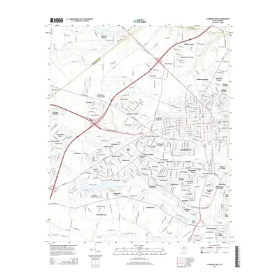
2014 Map of Florence West
USGS Topo · Published 2014About this map
Florence and its western suburbs appear as a dense network of residential subdivisions and transportation corridors in this early 21st-century survey. The landscape is heavily defined by the convergence of major routes including Us-52, Us-301, and Pampico Hwy, which facilitate the growth of numerous named neighborhoods such as Windsor Forest, Botany Acres, and Mayfair Acres. This period shows the intricate expansion of the city into former agricultural or timber lands, now fragmented by suburban development while still retaining its natural drainage patterns via Middle Swamp and Jeffries Creek.
Find a feature on this map
94 named features on this map. Tap any name to fly to it.
Don’t see what you’re looking for? This feature index may not catch every label — zoom into the map to look around manually.
Map Details
Editions of this 2014 Florence West Map
This is the sole edition of this map. No revisions or reprints were ever made.
Other maps of this area

1940 · Florence West
USGS Topo · 1:62,500

1940 · Florence East
USGS Topo · 1:62,500

1943 · Gum Swamp
USGS Topo · 1:62,500

1945 · Florence East
USGS Topo · 1:62,500

1945 · Florence West
USGS Topo · 1:62,500

1953 · Florence
USGS Topo · 1:250,000

1954 · Florence
USGS Topo · 1:250,000

1963 · Darlington East
USGS Topo · 1:24,000

1963 · Darlington West
USGS Topo · 1:24,000
1972 · Witherspoon Island
USGS Topo · 1:24,000