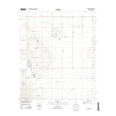
2013 Map of Florida Gap
USGS Topo · Published 2013About this map
Lewis Flats and the nearby Lewis Cem anchor the northeastern landscape of this Luna County region, where desert plains meet the dramatic rise of the Little Florida Mountains. The terrain is defined by complex drainage patterns like Coyote Arroyo and Headquarters Draw, which flow from high points such as Agate Point and Castle Rock. Evidence of historical passage through this arid environment is found in labels like Stagecoach Trl Se and Wagon Wheel Rd Se, which trace paths around the northern reaches of the Florida Mountains. To the south, the namesake Florida Gap provides a natural corridor between the mountain ranges, accompanied by vital water sources like The Gap Tank. This survey also documents the residential expansion of the area with dozens of local road names, ranging from Dulce Rd Se to Boothill Rd Se, reflecting the rural character of this high-altitude New Mexico basin.
Find a feature on this map
72 named features on this map. Tap any name to fly to it.
Don’t see what you’re looking for? This feature index may not catch every label — zoom into the map to look around manually.
Map Details
Editions of this 2013 Florida Gap Map
This is the sole edition of this map. No revisions or reprints were ever made.
Other maps of this area

1899 · Deming
USGS Topo · 1:125,000

1915 · Deming
USGS Topo · 1:125,000

1955 · Las Cruces
USGS Topo · 1:250,000

1958 · Las Cruces
USGS Topo · 1:250,000

1964 · Gym Peak
USGS Topo · 1:24,000

1964 · Florida Gap
USGS Topo · 1:24,000

1965 · South Peak
USGS Topo · 1:24,000

1965 · Deming East
USGS Topo · 1:24,000

1965 · Carne
USGS Topo · 1:24,000
1965 · Capitol Dome
USGS Topo · 1:24,000