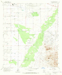
1965 Map of Capitol Dome
USGS Topo · Published 1967About this map
The Florida Mountains dominate the southeastern landscape of this mid-1960s survey, where the high desert floor meets the sharp relief of Dragon Ridge and Capitol Dome. This area reflects a classic New Mexico ranching and mining economy, anchored by the Spanish Stirrup Ranch and Capitol Dome Ranch. The map reveals a high concentration of extraction efforts concentrated in the foothills, notably at the Copper Queen Mine and Mahoney Mine, which sit near complex terrain features like Mexican Canyon and Lower Leap Canyon.
Find a feature on this map
27 named features on this map. Tap any name to fly to it.
Don’t see what you’re looking for? This feature index may not catch every label — zoom into the map to look around manually.
Map Details
Editions of this 1965 Capitol Dome Map
2 editions found
Other maps of this area

1899 · Deming
USGS Topo · 1:125,000

1915 · Deming
USGS Topo · 1:125,000

1955 · Las Cruces
USGS Topo · 1:250,000

1958 · Las Cruces
USGS Topo · 1:250,000

1964 · Gym Peak
USGS Topo · 1:24,000

1964 · Deming West
USGS Topo · 1:24,000

1964 · Florida Gap
USGS Topo · 1:24,000

1965 · South Peak
USGS Topo · 1:24,000

1965 · Deming East
USGS Topo · 1:24,000
1965 · Midway Butte
USGS Topo · 1:24,000