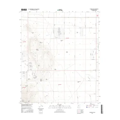
2017 Map of Florida Gap
USGS Topo · Published 2017About this map
The Little Florida Mountains dominate the western half of this landscape, rising sharply from the desert floor to reveal distinctive landmarks like Agate Point and the Little Needles Eye. This dramatic vertical terrain is cut by numerous drainages, including Mamie Canyon, Spring Canyon, and the appropriately named Windmill Canyon, all of which feed into the wider basin to the east. The arid character of the region is punctuated by vital water management features such as The Gap Tank, a small reservoir critical for the surrounding rangeland.
Find a feature on this map
67 named features on this map. Tap any name to fly to it.
Don’t see what you’re looking for? This feature index may not catch every label — zoom into the map to look around manually.
Map Details
Editions of this 2017 Florida Gap Map
This is the sole edition of this map. No revisions or reprints were ever made.
Other maps of this area

1899 · Deming
USGS Topo · 1:125,000

1915 · Deming
USGS Topo · 1:125,000

1955 · Las Cruces
USGS Topo · 1:250,000

1958 · Las Cruces
USGS Topo · 1:250,000

1964 · Gym Peak
USGS Topo · 1:24,000

1964 · Florida Gap
USGS Topo · 1:24,000

1965 · South Peak
USGS Topo · 1:24,000

1965 · Deming East
USGS Topo · 1:24,000

1965 · Carne
USGS Topo · 1:24,000
1965 · Capitol Dome
USGS Topo · 1:24,000