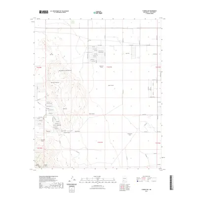
2023 Map of Florida Gap
USGS Topo · Published 2023About this map
Lewis Flats and the surrounding high desert of Luna County are documented here as they existed in the early 2020s. This landscape is defined by the striking geology of the Little Florida Mountains and the northern reach of the Florida Mountains, where prominent landmarks such as Florida Peak, Agate Point, and Castle Rock rise above the basin floor. The settlement pattern reflects the modern rural West, with a network of numbered and named desert roads like Co RD Se b041 and Saguaro RD serving isolated properties and homesteads.
Find a feature on this map
71 named features on this map. Tap any name to fly to it.
Don’t see what you’re looking for? This feature index may not catch every label — zoom into the map to look around manually.
Map Details
Editions of this 2023 Florida Gap Map
This is the sole edition of this map. No revisions or reprints were ever made.
Other maps of this area

1899 · Deming
USGS Topo · 1:125,000

1915 · Deming
USGS Topo · 1:125,000

1955 · Las Cruces
USGS Topo · 1:250,000

1958 · Las Cruces
USGS Topo · 1:250,000

1964 · Gym Peak
USGS Topo · 1:24,000

1964 · Florida Gap
USGS Topo · 1:24,000

1965 · South Peak
USGS Topo · 1:24,000

1965 · Deming East
USGS Topo · 1:24,000

1965 · Carne
USGS Topo · 1:24,000
1965 · Capitol Dome
USGS Topo · 1:24,000