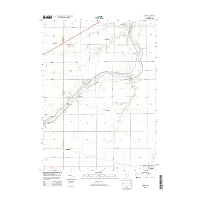
2013 Map of Florida
USGS Topo · Published 2013About this map
The Maumee River defines the heart of this Henry County landscape, carving a wide path that separates the northern uplands from the southern flats. The village of Florida sits prominently on the northern bank, serving as a focal point for a network of rural roads such as Jewell Rd and Co Road L. Small islands like Girty Island and Sand Island break the river's flow, illustrating the natural morphology of the waterway before it reaches the outskirts of Napoleon in the northeast.
Find a feature on this map
102 named features on this map. Tap any name to fly to it.
Don’t see what you’re looking for? This feature index may not catch every label — zoom into the map to look around manually.
Map Details
Editions of this 2013 Florida Map
This is the sole edition of this map. No revisions or reprints were ever made.
Other maps of this area

1907 · Defiance
USGS Topo · 1:62,500

1908 · Ottawa
USGS Topo · 1:62,500

1908 · Napoleon
USGS Topo · 1:62,500

1909 · Defiance
USGS Topo · 1:62,500

1909 · Continental
USGS Topo · 1:62,500

1953 · Fort Wayne
USGS Topo · 1:250,000

1956 · Fort Wayne
USGS Topo · 1:250,000

1959 · Defiance East
USGS Topo · 1:24,000
1959 · Ridgeville Corners
USGS Topo · 1:24,000

1959 · Florida
USGS Topo · 1:24,000