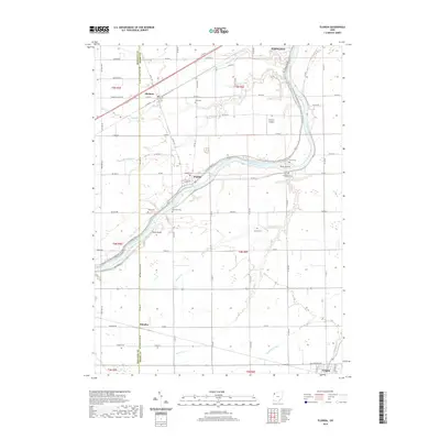
2019 Map of Florida
USGS Topo · Published 2019About this map
The Maumee River defines the landscape of this Henry and Defiance County borderland, winding past Girty Island and Sand Island as it flows toward the northeast. The small village of Florida occupies a prominent bend in the river, situated where the historic Independence Dam Tow Path and the N Country National Scenic Trail follow the river’s north bank. The surrounding agricultural plain is dotted with ancestral burial grounds, including Huston Cem and Brinkman Cem, reflecting generations of rural settlement.
Find a feature on this map
60 named features on this map. Tap any name to fly to it.
Don’t see what you’re looking for? This feature index may not catch every label — zoom into the map to look around manually.
Map Details
Editions of this 2019 Florida Map
This is the sole edition of this map. No revisions or reprints were ever made.
Other maps of this area

1907 · Defiance
USGS Topo · 1:62,500

1908 · Ottawa
USGS Topo · 1:62,500

1908 · Napoleon
USGS Topo · 1:62,500

1909 · Defiance
USGS Topo · 1:62,500

1909 · Continental
USGS Topo · 1:62,500

1953 · Fort Wayne
USGS Topo · 1:250,000

1956 · Fort Wayne
USGS Topo · 1:250,000

1959 · Defiance East
USGS Topo · 1:24,000
1959 · Ridgeville Corners
USGS Topo · 1:24,000

1959 · Florida
USGS Topo · 1:24,000