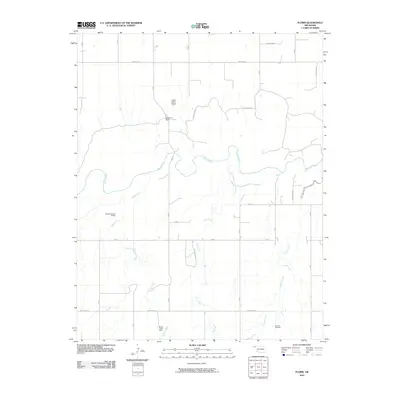
2010 Map of Floris
USGS Topo · Published 2010About this map
The Beaver River meanders across this High Plains landscape in Beaver County, defining a region where water management and ranching operations are central to the terrain. This 2010 survey illustrates the sparse but deliberate settlement pattern of the Oklahoma Panhandle, where large holdings like Blakemore Ranch and Willow Creek Ranch are connected by a grid of rural routes. Significant water features such as Willow Creek, Elm Creek, and Dugout Creek feed into the river system, while the Davis Number 5 Dam indicates local efforts to control the flow of these vital ephemeral or seasonal streams. The inclusion of the T Bar T Ranch Airport highlights the necessity of private aviation for navigating this expansive ranching country, while the Overton Cemetery remains as a focal point for genealogical research and local heritage.
Find a feature on this map
27 named features on this map. Tap any name to fly to it.
Don’t see what you’re looking for? This feature index may not catch every label — zoom into the map to look around manually.
Map Details
Editions of this 2010 Floris Map
This is the sole edition of this map. No revisions or reprints were ever made.
Other maps of this area

1954 · Perryton
USGS Topo · 1:250,000

1958 · Perryton
USGS Topo · 1:250,000

1973 · Balko
USGS Topo · 1:24,000

1973 · Boyd
USGS Topo · 1:24,000

1973 · Balko NE
USGS Topo · 1:24,000

1973 · Floris
USGS Topo · 1:24,000
1973 · Forgan
USGS Topo · 1:24,000

1973 · Turpin East
USGS Topo · 1:24,000

1973 · Beaver
USGS Topo · 1:24,000
1973 · Beaver NW
USGS Topo · 1:24,000