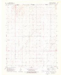
1973 Map of Beaver NW
USGS Topo · Published 1976About this map
The High Plains of the Oklahoma Panhandle meet the Kansas border in this 1970s topographical survey, characterized by a transition from ranching to an intensive energy-extraction landscape. Scattered across the flat terrain are landmarks of local community life, including Bethel Ch and the Midway Cem, which reflect the early settlement patterns of Beaver County. The industrial shift of the mid-20th century is evident in the proliferation of Gas Wells and Oil Wells that now dot the sections once dominated by operations like the L T Ranch. This map documents a period when local infrastructure, such as a prominent Radio Tower, was becoming more visible against the expansive horizon while the historic state line between Kansas and Oklahoma continued to define the administrative character of this rural corridor.
Find a feature on this map
10 named features on this map. Tap any name to fly to it.
Don’t see what you’re looking for? This feature index may not catch every label — zoom into the map to look around manually.
Map Details
Editions of this 1973 Beaver NW Map
This is the sole edition of this map. No revisions or reprints were ever made.
Other maps of this area

1954 · Perryton
USGS Topo · 1:250,000

1955 · Dodge City
USGS Topo · 1:250,000

1958 · Perryton
USGS Topo · 1:250,000

1958 · Dodge City
USGS Topo · 1:250,000

1959 · Dodge City
USGS Topo · 1:250,000

1963 · Kismet SE
USGS Topo · 1:24,000

1971 · Kismet SW
USGS Topo · 1:24,000

1971 · Hayne
USGS Topo · 1:24,000

1973 · Floris
USGS Topo · 1:24,000
1973 · Forgan
USGS Topo · 1:24,000