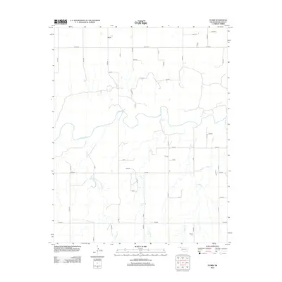
2012 Map of Floris
USGS Topo · Published 2012About this map
Floris serves as the primary landmark in this section of the Oklahoma Panhandle, situated in the northern portion of the quadrangle. The landscape is defined by the winding course of the Beaver River, which flows eastward and is fed by several local drainages. To the south and east, Elm Cr, Willow Cr, and Dugout Cr cut through the plains, creating a network of seasonal watercourses. The area is laid out in a rigorous section-line grid, with roads such as Beaver Rd providing the backbone for travel through this agricultural region. For those researching local burials or family history, the Overton Cem is situated in the southeastern corner, offering a specific point of reference for the surrounding rural community. The map illustrates the sparsely populated nature of Beaver County, where small settlements and cemeteries are the few breaks in an expansive drainage system.
Find a feature on this map
44 named features on this map. Tap any name to fly to it.
Don’t see what you’re looking for? This feature index may not catch every label — zoom into the map to look around manually.
Map Details
Editions of this 2012 Floris Map
This is the sole edition of this map. No revisions or reprints were ever made.
Other maps of this area

1954 · Perryton
USGS Topo · 1:250,000

1958 · Perryton
USGS Topo · 1:250,000

1973 · Balko
USGS Topo · 1:24,000

1973 · Boyd
USGS Topo · 1:24,000

1973 · Balko NE
USGS Topo · 1:24,000

1973 · Floris
USGS Topo · 1:24,000
1973 · Forgan
USGS Topo · 1:24,000

1973 · Turpin East
USGS Topo · 1:24,000

1973 · Beaver
USGS Topo · 1:24,000
1973 · Beaver NW
USGS Topo · 1:24,000