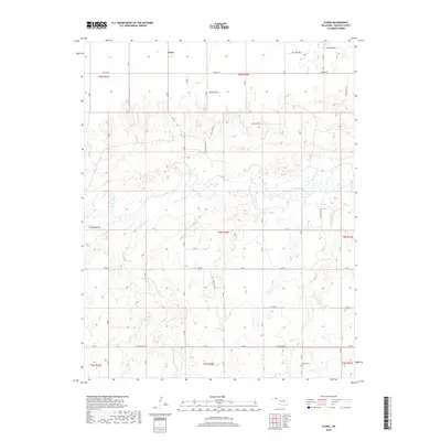
2018 Map of Floris
USGS Topo · Published 2018About this map
Floris serves as the focal point for this survey of the Oklahoma Panhandle, where the landscape is defined by the winding course of the Beaver River. The river valley and its intricate network of tributaries, including Willow Cr and Elm Cr, create a distinct contrast against the high plains topography of Beaver County. Human settlement and heritage are anchored by the Overton Cem in the southern portion of the quadrangle, a significant landmark for those tracing local family lineages in this part of the state. The layout of the region follows a rigid section-line grid, prominently featuring Beaver Rd as a primary east-west corridor. This 2018 data provides a clear view of the modern rural infrastructure and water drainage patterns, such as those near Dugout Cr, as they existed in the early 21st century.
Find a feature on this map
15 named features on this map. Tap any name to fly to it.
Don’t see what you’re looking for? This feature index may not catch every label — zoom into the map to look around manually.
Map Details
Editions of this 2018 Floris Map
This is the sole edition of this map. No revisions or reprints were ever made.
Other maps of this area

1954 · Perryton
USGS Topo · 1:250,000

1958 · Perryton
USGS Topo · 1:250,000

1973 · Balko
USGS Topo · 1:24,000

1973 · Boyd
USGS Topo · 1:24,000

1973 · Balko NE
USGS Topo · 1:24,000

1973 · Floris
USGS Topo · 1:24,000
1973 · Forgan
USGS Topo · 1:24,000

1973 · Turpin East
USGS Topo · 1:24,000

1973 · Beaver
USGS Topo · 1:24,000
1973 · Beaver NW
USGS Topo · 1:24,000