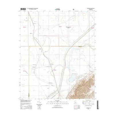
2015 Map of Floweree
USGS Topo · Published 2015About this map
The alluvial landscape of the Mississippi Delta is defined here by the winding course of the Yazoo River and its intricate network of oxbow lakes and drainage creeks. Small settlements like Floweree, Hardee, and Katzenmeyer are situated along the low-lying terrain, connected by rural routes such as Floweree Rd and Anderson Tully Rd. This region, split by the Issaquena Co Warren Co boundary, exhibits a pattern of land use focused on the fertile floodplains between the river and the dense woodlands of the Delta National Forest. To the south, the topography shifts at Haynes Bluff, where the elevation rises significantly above the river bottom. Aviation and local infrastructure are represented by the Whitaker Airport, while numerous water bodies including Hardee Lake, Miller Lake, and Panther Lake illustrate the hydrological complexity of this riverine environment.
Find a feature on this map
40 named features on this map. Tap any name to fly to it.
Don’t see what you’re looking for? This feature index may not catch every label — zoom into the map to look around manually.
Map Details
Editions of this 2015 Floweree Map
This is the sole edition of this map. No revisions or reprints were ever made.
Other maps of this area

1918 · Vicksburg
USGS Topo · 1:62,500

1938 · Edwards
USGS Topo · 1:62,500

1939 · Onward
USGS Topo · 1:62,500

1940 · Mechanicsburg
USGS Topo · 1:62,500

1941 · Vicksburg
USGS Topo · 1:62,500

1955 · Jackson
USGS Topo · 1:250,000

1961 · Jackson
USGS Topo · 1:250,000

1962 · Jackson
USGS Topo · 1:250,000

1962 · Redwood
USGS Topo · 1:24,000
1962 · Long Lake
USGS Topo · 1:24,000